
Earth’s water focus of latest NASA mission

A satellite built to observe nearly all the water on Earth for the first time has lifted off on a NASA-led mission to shed new light on the effects of climate change.
The Surface Water & Ocean Topography (SWOT) spacecraft launched on a SpaceX rocket from Vandenberg Space Force Base in California for a three-year survey.
The satellite will measure the water height in freshwater bodies and oceans on more than 90% of Earth’s surface. This information will provide insights into how a changing climate affects lakes, rivers, and reservoirs, how the ocean influences climate change, and how communities can better prepare for disasters, such as floods.
The international mission is being undertaken by NASA and the French space agency Centre National d’Études Spatiales, with contributions from the Canadian Space Agency and the UK Space Agency.
NASA earth science division director Karen St. Germain said: “We’re eager to see SWOT in action. This satellite embodies how we are improving life on Earth through science and technological innovations. The data it will provide is essential to better understand how Earth’s air, water, and ecosystems interact – and how people can thrive on our changing planet.”
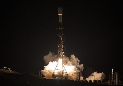
After SWOT separated from the second stage of a SpaceX Falcon 9 rocket on 16 December 2022, ground controllers successfully acquired the satellite’s signal. Initial telemetry reports showed the spacecraft in good health and SWOT will now undergo a series of checks and calibrations before it starts collecting data in about six months.
NASA administrator Bill Nelson said, “Warming seas, extreme weather, more severe wildfires are only some of the consequences humanity is facing due to climate change. The climate crisis requires an all-hands-on-deck approach and SWOT is the realisation of a long-standing international partnership that will ultimately better equip communities to face these challenges.”
SWOT will cover all of Earth’s surface between the latitudes of 78 degrees south and 78 degrees north at least once every 21 days, sending back about one terabyte of unprocessed data per day. The scientific heart of the spacecraft is an instrument called the Ka-band radar interferometer (KaRIn), which marks a major technological advance.
KaRIn bounces radar pulses off the water’s surface and receives the return signal using two antennas on either side of the spacecraft. This arrangement, of one signal and two antennas, will enable engineers to precisely determine the height of the water’s surface across two swaths at a time, each of them 50km wide.
“The data is essential to better understand how Earth’s air, water, and ecosystems interact – and how people can thrive on our changing planet.”

Among the many benefits the SWOT mission will provide is a significantly clearer picture of Earth’s freshwater bodies. It will provide data on more than 95% of the world’s lakes larger than 62,500m2 and rivers wider than 100m across.
Currently, freshwater researchers only have reliable measurements for a few thousand lakes around the world. SWOT will push that number into the millions. Along the coast, SWOT will also provide information and tracking on sea level height and change over time, filling in observational gaps in areas that do not have tide gauges or other instruments that measure sea level changes.
SWOT measurements will also help researchers, policymakers, and resource managers better assess and plan for events including floods and droughts, which directly impact communities and coastal ecosystems. By providing information on where the water is, where it is coming from, and where it is going, researchers can improve flood projections for rivers and monitor drought effects on lakes and reservoirs.
Laurie Leshin, director of NASA’s Jet Propulsion Laboratory, said, “SWOT will provide vital information, given the urgent challenges posed by climate change and sea level rise.
“That SWOT will fill gaps in our knowledge and inform future action is the direct result of commitment, innovation, and collaboration going back many years. We’re excited to get SWOT science underway.”